When we want to make a map of a high-detail country division (for example, counties in US or "municipios" in Spain) it often happens that in the same country there are a lot of them with the same nomenclature.
For example, there are 9 counties named Benton in US.
If I upload my excel file with only "Benton" written in the geocoded column, TargetMap will not be able to guess which Benton am I referring
So, what should we do to upload an excel file by territory name and be able to locate each record in the proper Benton?
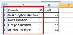
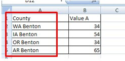
It's quite easy. Our geocoded column should contain "State + County" or "State abbreviation + county" In this case, both "Arizona Benton" and "AR Benton" will locate your record in the proper Benton.
Our excel file should look like one of these. Both will work perfect.
Our excel file should look like one of these. Both will work perfect.


