When we want to make a map of a high-detail country division (for example, counties in US or "municipios" in Spain) it often happens that in the same country there are a lot of them with the same nomenclature.
For example, there are 9 counties named Benton in US.
If I upload my excel file with only "Benton" written in the geocoded column, TargetMap will not be able to guess which Benton am I referring
So, what should we do to upload an excel file by territory name and be able to locate each record in the proper Benton?
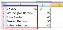
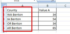
It's quite easy. Our geocoded column should contain "State + County" or "State abbreviation + county" In this case, both "Arizona Benton" and "AR Benton" will locate your record in the proper Benton.
Our excel file should look like one of these. Both will work perfect.
Our excel file should look like one of these. Both will work perfect.


tanks from México, we have the same problems with our conties
ReplyDeleteHi
ReplyDeleteIn Argentina have the same problem, but I can not solve.
The system can not import the column containing "province + department"
For example, "Cordoba, General Roca" Each column works well as individuals
Another solution know? Or does it not work for all countries?
You can see the map in http://www.targetmap.com/viewer.aspx?reportId=37255
Thank you
Hi,
DeleteIt only works for some countries because it has to be configured in the map.
Our apologies for the inconveniences,
Best regards,
The TargetMap Crew
Buenos días, muy amable por responder.
ReplyDeleteEvidentemente el mapa de Argentina no está configurado para esta funcionalidad.
Este tema nos limita y no nos permitiría utilizar TargetMap. Es una pena porque funciona muy bien.
¿Hay posibilidades de configurar el mapa de Argentina?
Desde ya iríamos a la versión paga si esto se soluciona.